The Ganga river system is the largest river system in India, and it influences the people directly and indirectly. The Ganga River is related to the Indian civilization and culture. Indians consider that the Ganga’s water can shed sins and bring salvation. From age immemorial, it influences the people.
Ganga basin, which is an example of “Hydraulic civilization”, holds about 26 per cent of the land and 43 per cent of the population.
Name of River Ganga
In ancient India, people knew Ganga by the name Susari or the river of the gods.
After Devaprayag, the river is known as Ganga. In the English language, people know the River Ganga as the Ganges.
Origin of River Ganga System
The Ganga originates from high Himalayan glaciers. Four main Himalayan sources originate from glaciers.
Out of the four, Gangotri Glacier is the most important. The Gaumukh at Gangotri Glacier in the Uttarakasi district of Uttarakhand is considered the first source of Ganga. It is from this glacier that the River Ganga originates as Bhagirathi.
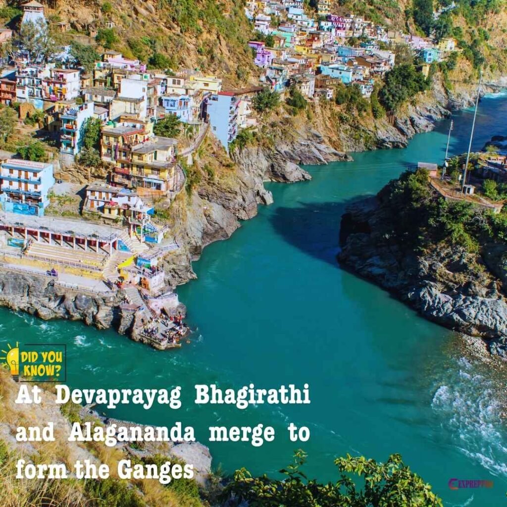
At Devprayag, the river Bhagirathi meets Alakananda, and after Devprayag, the river is known as Ganga.
Tributaries of River Ganga
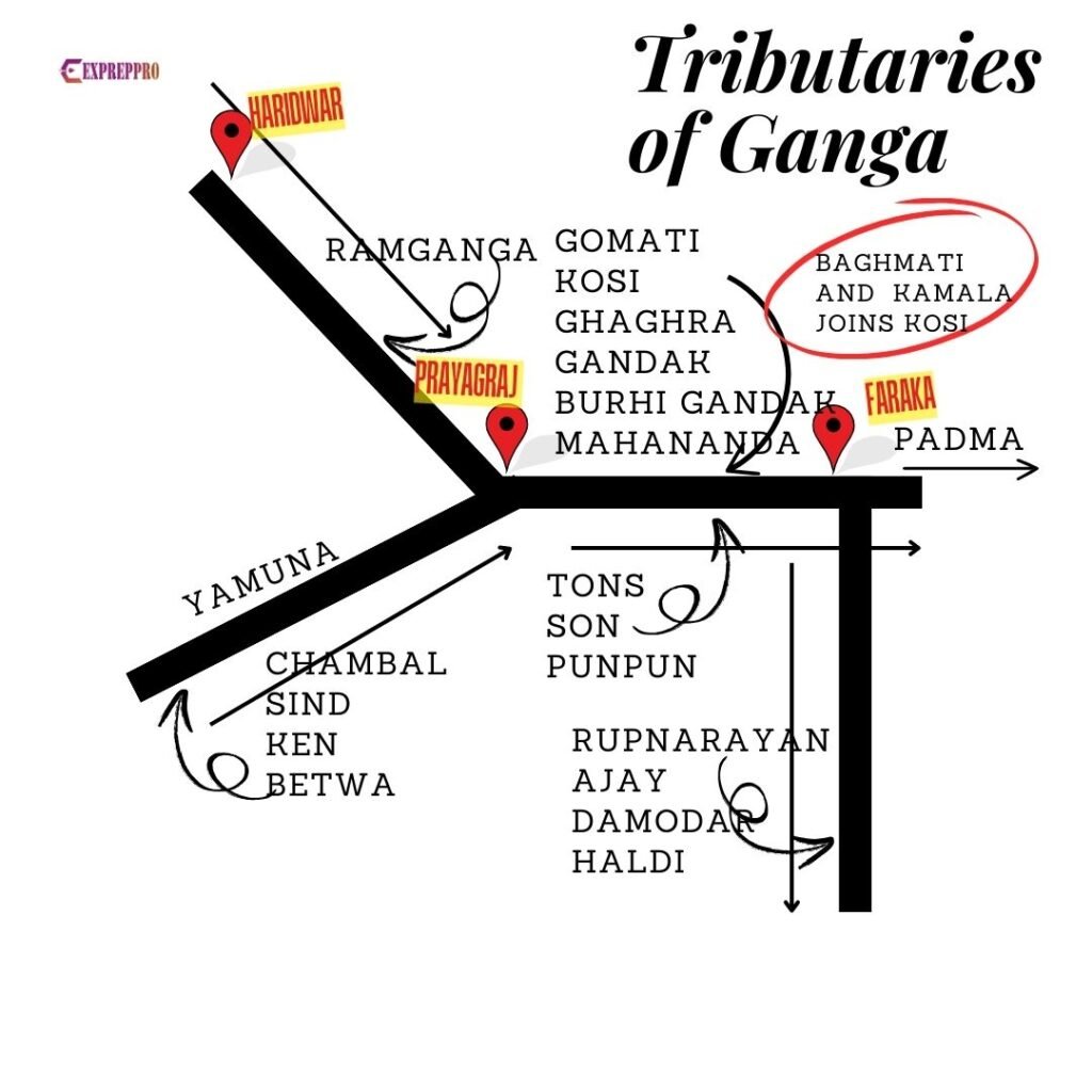
After travelling around 300 kilometres from its source, the river enters Haridwar. From Haridwar, Ganga flows south and southeast to reach Prayagraj.
From Haridwar, the river flows in a well-defined valley, and no significant tributary joins until Kanuj. At Kanuj, the Ramganga comes from the north.
Yamuna River
Yamuna, the largest tributary of Ganga, joins on its south bank at Prayagraj. River Yamuna is important because even though it originates from the Himalayas, it is this river that collects the discharge of several rivers of the Indian peninsula. It also contributes a large volume of sediments to the Ganga.
Between the Prayagraj and Patna rivers, like Gomati and Ghaghra, Gandak joins from the north. Punpun, Phalga joins from the south.
The river then passes the basaltic Rajmahal traprocks of the Rajmahal gap and enters Farakka. Now, it splits into distributaries.
How many distributaries does Ganga have?
The two important distributaries are Padma and Hugli or Bhagirathi.
- Padma: Enters Bangladesh and joins Bhramaputra(Jamuna).
- Bhagirathi or Hugli: It flows south through India. Hugli collects water from many rivers like Ajay, Damodar, Rupnarayan, and Haldi, which flow from the northeastern edge of the Indian peninsula.
Length of River Ganga
The total length from its source to Hugli is 2525 kilometres.
Out of 2525 kilometer, 310 kilometer is in Uttarakhand, 1140 kilometer is in Uttarpradesh, 445 kilometer is in Bihar and 520 kilometer is in West Bengal. The river flows with an average gradient of 2.77 meters per kilometre.
Hydrology
This river is a rainfed seasonal river sustained by the summer rain of the Indian monsoon. The wet southwest monsoon brings 70 to 80 per cent of annual rainfall.
The average annual rainfall decreases gradually from east to west, from about 1600mm in Bengal to about 500mm in western Uttar Pradesh and Haryana. The southwestern part of the basin has low rainfall of about 500-700mm.
The water discharge varies not only seasonally but also from day to day on certain occasions. The highest flow occurs from July to October during the monsoon period. This period also displays many peaks of very high discharge.
The river contributes about 460 * 109 m3 of water per year to the Sunderban delta region.
The mean peak discharge of the undivided river near Farakka is 70547 m3 per second.
The estimated discharge of the Ganga River from Gangotri Glacier is about 30 to 20 m3 per second. At Devprayag, the average peak flow is about 1775m3 per second.
At Rishikesh, the monthly discharge is low from January to April, and increases in May due to glacier melt.
Flooding
Annual flooding is characteristic of all rivers in the Ganga Plain. Water rises during the wet monsoon season, but its high bank usually restricts flood water from spreading. Over-topping and lateral spreading occur only in certain areas.
The floodplain is usually 0.5 to 2 kilometres wide, sloping gently away from the levees and ending against a steep, leading to the next alluvial surface.
Temperature and PH
The average temperature of Ganga river water in the Himalayan region is between 2 degrees to 8 degrees Celsius, depending on the season. When the water reaches the plain, it will rise from 15 to 26 degrees Celsius. It may even rise to 32 degrees celsius in the lower Ganga channel.
The PH is generally over 7.5 and may reach 8 in the hot season. In short, the water is alkaline. In the lower Ganga, PH is 7 to 7.5.