Indus Water Treaty is a milestone water-sharing agreement between India and Pakistan designated to govern the use of the Indus River water. The Indus Water Treaty was signed in Karachi, Pakistan, on September 19, 1960.
The History of Indus Water Dispute
The tension over Indus water between various parties in British-controlled India was not uncommon. When India and Pakistan gained independence, tensions over the Indus water became serious.
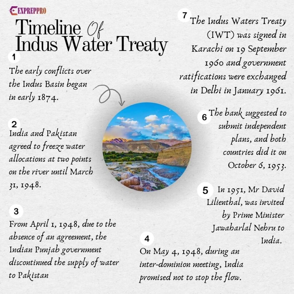
The early conflicts over the Indus Basin began in early 1874. This problem was solved temporarily when British and Indian princes agreed on a shared percentage of water each would receive from the Hathmatee Basin for irrigation purposes. The princely states of Bahawalpur, Bilaspur and Bikaner, along with British-controlled Punjab and Sind, were involved in these disputes.
Indus Commission or B.N Rau Commission
A commission to study Indus River disputes was established in 1941 under the chairmanship of Justice B.N. Rau. He submitted the report in July 1942.
The water usage by Punjab was likely to cause material injury to the inundation canals in Sind, especially in the month of September. The commission also suggested recommendations on the sharing of the
Indus waters during the winter season. But both Sind and Punjab rejected the recommendations.
Later, to find a solution, the British Indian government referred the dispute to the British Government in London. In early 1947, it was decided to refer the dispute to the Secretary of State for India. But the Secretary of State for India didn’t take any action because by the time India and Pakistan gained independence.
Standstill Agreement of 1947
As a temporary solution, the new dominion of India and Pakistan agreed to sign a standstill agreement in the autumn of 1947.
According to this agreement, both sides agreed to freeze water allocations at two points on the river until March 31, 1948. This arrangement allowed water from headworks in India to flow into Pakistan till the agreement expired.
From April 1, 1948, due to the absence of an agreement, the Indian Punjab government discontinued the supply of water to the Dipalpur canal and the main branches of the Upper Bari Doab canal.
Delhi Agreement On Indus Water
Later, on May 4, 1948, during an inter-dominion meeting, India promised not to stop the flow. India also made it clear that Pakistan could not claim any share of these waters as a matter of right. In this session, both parties signed an agreement which assured no stoppage of water without giving it time to develop alternate sources.
Pakistan agreed to pay for water under the standstill agreement of 1947. According to them, they had the rights of prior appropriation, and the payments were only to cover operational and management expenses.
India objected to the rights of prior appropriation claimed by Pakistan. Since Pakistan was willing to pay for water, it had recognised India’s proprietary right to the Indus water.
In June 1947, Pakistan again expressed their displeasure by raising its voice for the equitable apportionment of all common waters. When claims and counterclaims strengthened, a solution became nearly impossible. To find a solution, Pakistan favoured the International Court of Justice. However, India preferred a commission of equal judges from both countries, as it was the best way to resolve issues before resorting to a third party.
The situation became complete when the government of West Punjab (the Punjab province of Pakistan) faced difficulty in depositing the ad-hoc sum with the Reserve Bank of India.
At last, both countries approached the World Bank with separate applications for a loan to develop their portion of the Sutlej River/ this move later brought the World Bank into the picture.
David Lilienthal’s Role
In 1951, Mr David Lilienthal, former chairman of the Tennessee Valley Authority (TVA), was invited by Prime Minister Jawaharlal Nehru to India. The idea was to find a possible solution by replicating the TVA model for India’s water problems. On his way back, he visited Pakistan at the suggestion of Mr Walter Lippman, an influential political commentator and writer. Lippman strongly believed that Mr Lilienthal could find a solution.
After his return, Mr Lilienthal wrote an article highlighting his recommendations and suggestions in Colliers.
Main Suggestion from Lilienthal’s Article
- The Indus Basin should be developed cooperatively with the idea of promoting the economic development of the Indus region.
- The entire Indus basin should be viewed as a single unit.
- Problems must be solved on a functional plane without any relation to past negotiations and claims.
Mr Eugene Black, the president of the World Bank, read this article. Later, Mr Eugene decided to take help from Lilienthal and contacted both PMs to accept the essential principles pointed out by Lilienthal.
Working Party On Indus Waters
Black suggested appointing two senior engineers from India and Pakistan to work on a plan for Indus development. The bank will provide a consultant for help. Both sides accepted this proposal.
The first meeting of the Working Party was convened in Washington, D.C., in May 1952. The bank suggested submitting independent plans, and both countries did it on October 6, 1953.
The bank also conducted its own independent studies to examine the issue and confirm that there was no surplus water in the Western rivers, especially during the critical crop periods.
Outline of Working Party’s Suggestion
- Determine the total water supplies of the Indus Basin and its subdivision into categories.
- Determine water requirements.
- Prepare a comprehensive plan.
- Prepare cost estimates of new dams and engineering works.
- The working party will collect and verify the accuracy of all data. If data is unavailable, the working party will discuss the matter and reach an agreement.
After the Washington meeting, the next meetings were convened in Karachi (November 1952) and New Delhi (January 1953), which ended in the inability to strike an amicable agreement.
The World Bank’s Proposal
- The entire flow of the Eastern rivers, i.e. the Ravi, Beas and Sutlej, will be allocated to India.
- All of the Western rivers, i.e. Indus, Jhelum and Chenab, except for a small amount from Jhelum, will be allocated to Pakistan.
- Both sides would agree on a transition period. So that Pakistan can complete the link canals dividing the watershed, during which India would continue to allow the water historically used by Pakistan to flow from the Eastern rivers.
In February 1954, the World Bank concluded it. On March 25, 1954, India accepted the proposal. On July 28 1954, Pakistan also accepted it.
Finally, A Treaty
At last, the Indus Water Treaty was signed in Karachi, Pakistan, on September 19, 1960, by Prime Minister Jawaharlal Nehru and Field Marshal Ayub Khan.
Both exchanged the government ratification in New Delhi in January 1961.
Indus Water Treaty
The Indus Water Treaty contains 12 articles covering 79 paragraphs and 8 detailed annexes. India acquired the exclusive right over the eastern rivers with a transition period, i.e., from April 1, 1960, to March 31, 1970. During the transition period, Pakistan can utilise water from the eastern rivers, as per Annexure H.
India agreed to make a fixed contribution of £ 62 million towards the expense of the replacement works in 10 equal annual instalments, beginning from 1960, payable on November 1 of each year.
Pakistan received unrestricted use of the Western rivers, and India will not obstruct the water flow.
Under Article VI, both countries will exchange data on the Indus River water. As per Article VIII of the Indus Treaty, both countries will form a permanent post of Commissioners of Indus Waters (a competent senior engineer) and a Permanent Indus Commission.
The Indus water treaty also provided provisions for three dams, eight link canals, three barrages, and 2,500 tube wells to be built in Pakistan.
Functions Of The Permanent Indus Commission
- Establish and promote cooperative arrangements for implementing the Indus Treaty.
- Promote cooperation between India and Pakistan on the Indus River.
- Resolve the questions that may appear between the Parties concerning the interpretation or implementation of the Treaty.
- Submit an annual report before June 1 of every year to both the Governments of India and Pakistan.
- Both commissioners would meet annually to perform their duties.
Arbitration
The Indus water treaty also provides for arbitration if a problem remains unresolved.
Suppose the Permanent Indus Commission is unable to resolve a specific problem. In that case, provisions have been made for reference to a Neutral Expert under Article IX and Annexure E. If the Neutral Expert fails to solve the problem, a Court of Arbitration can be convened under Article IX and Annexure G.
Current Status Of Indus Water Treaty
When terrorists killed 26 Innocent Indians in Pahalgam in Jammu and Kashmir, India decided to keep the Indus Treaty in Abeyence. The Indian government has stopped sharing all data related to the water flows of the western rivers to Pakistan. When Pakistan approached the World Bank, its president ruled out any intervention in the suspension of the Indus Waters Treaty.