The cessation of the typical upwelling of cold deep water off the coast of Peru is generally known as El Nino, and the roughly opposite condition is called La Nina. This El Nino phenomenon can affect the global climate negatively and positively. So, some parts of the world face drought while others face above-average rainfall and floods.
INTRODUCTION
In 1897, Hildebrandsson noticed that the atmospheric pressure fluctuations in Sydney were out of phase with those in Bueno Aires.
Later, in 1902, Lockyer and Lockyer (father and son) used data from around the world and estimated the period of the oscillation to be 3.8 years.
Sir Gilbert Walker termed these fluctuations the Southern Oscillation. He, along with Bliss & team, found out that the Southern Oscillation involves far more than a seesaw in the surface pressure differences across the Pacific Ocean. This oscillation can create significant changes across the world.
EL NINO MEANING
The El Nino came from the Spanish language, meaning the child Christ. It was derived from ” Corriente de Nino“, the name local Peruvian fishermen gave to a warm Southward flowing coastal ocean current that became prominent each year during Christmas.
WHAT IS EL NINO?
The unusual surface water warming in the Eastern tropical Pacific Ocean is called El Nino.
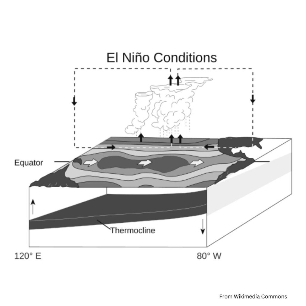
During normal conditions, strong Westward blowing trade wind moves very warm ocean water to the Western part of the Pacific and pile up near the Western equatorial low. This movement causes a normal upwelling along the South American coast.
During an El Nino event, the Easterly trade winds weaken with atmospheric pressure change, resulting in an Eastward surge of warm waters. This results in an increase in sea surface temperature and a rise in actual sea level off the tropical Western coasts of America.
Now you will have a question in your mind. How did an event that creates adverse changes across the globe get the name of child Christ?
At first, this name was given to the warm, seasonal current that appears off the coast of Peru around Christmas time. Every couple of years, this current becomes more intense than usual and brings heavy rain to the arid coastal regions of Peu and Ecuador. Due to this, local people named this phenomenon El Nino. It was originally known as an “año de abundancia” or “ year of abundance“.
Only after 1957( it was an international geophysical year of intensive measurements of the earth) the world realised that it is not a local phenomenon.
When there is an increase in sea surface temperature (an increase from value 3.4), the seal level pressure over the Southeast Pacific decreases, and the South Indian Ocean increases, which corresponds to weak Walker Circulation. During El Nino years, there will be an Eastward shift of Wlaker Circulation.
During El Nino, the South westerlies over the Arabian Sea are weakened, which leads to weak monsoon circulation and reduces rainfall over India.
LIFE CYCLE OF EL NINO
El Nino typically has four distinct phases
- Precursor
- Onset
- Growth
- Decay
- Precursor starts with an intensification of the prevailing weather patterns.
- The onset of El Nino occurs around Christmas time.
- During growth, the sea surface temperature of the Western Pacific Ocean drops, and the sea surface temperature of the Eastern Pacific Ocean rises. This phase is the continuation of the onset.
- The sea surface temperature reaches a maximum in June. The flow of warm water from the West Pacific to the East Pacific leads to a rise in sea level and pushes the thermocline deeper. The wind starts to blow from the West to the East Pacific, causing a decrease in rainfall over Indonesia and an increase in rainfall over the Central, East Pacific, and South American Pacific coasts.
- After reaching about a year after the onset, Westerly wind anomalies start weakening, and the phenomenon enters the decay phase.
After a year and a half after the onset of El Nino, the weather returns to normal.

CATEGORIES OF EL NINO
El Nino can be categorised into four
- Strong
- Moderate
- Weak
- Very Weak
There are still considerable differences within each category. For example, the strong El Nino of 1972 was more intense than that of 1976, but it was of shorter duration.
WHAT IS LA NINA?
In short, La Nina is a phenomenon opposite to El Nino.
In this situation, sea surface temperature in the Central and West Pacific ocean is reduced to a lower level than average level.
This fall is due to the change in the South Pacific subtropical high. Subtropical high becomes very strong during high sun and results in abnormally strong easterly trade winds.
The wind moves a higher amount of warm water westward and enhances upwelling along West continental coasts.
WHAT IS SOUTHERN OSCILLATION?
During the El Nino event, the low-pressure system is replaced by a weak high-pressure zone. Pressure drops in the equatorial zone of the Eastern Pacific, strengthening the equatorial trough.
The new low-pressure region will receive abundant rainfall. This shift in the pressure pattern between the South East Pacific and Indonesia is known as Southern Oscillation.
The effect of Southern Oscillation is felt throughout the globe.
Example: Zimbabwe, a country located in the South of the African continent, usually gets the highest rainfall and highest maise yield during El Nino years.
The warm winter in Canada is also related to the pressure pattern contributed to the Southern Oscillation.
HOW DID GILBERT WALKER DISCOVER THE SOUTHERN OSCILLATION PHENOMENON?
In 1904, Gilbert Walker was the director general of Observatories in India. 1899 – 1900, India faced a notorious drought followed by famine, which claimed more than a million lives. This incident drew his attention. According to him, the lack of summer monsoon rainfall, which caused these droughts, might be predictable.
He gathered data from all over the world and published two papers in 194 and 1932. He described this phenomenon in these papers as the ” Southern Oscillation“.
When the pressure is unusually low in the southeastern tropical Pacific, it will be high over the western tropical Pacific and Indian Ocean and vice versa.
The high pressure over India corresponded with deficient summer monsoon rainfall, whereas low pressure corresponded with abundant summer monsoon rainfall.
OCEANIC NINO INDEX
It is the primary index created by NOAA for tracking El Nino Southern Oscillation.
This index tracks the three-month sea surface temperature average in the East-central tropical Pacific ( between 120 degrees and 170 degrees West).
A value of +0.5 or greater shows El Nino, and -0.5 or lower indicates La Nina.


